 The BLM Interpretive Center
The plaza in front of the building gives visitors a sense of which direction people headed out of Fort Benton after getting off of a Missouri River steamboat in the 19th century. Virginia City, Last Chance Gulch, the Whoop Up Trail into Canada, Cow Island, and other places only accessible by wagon until the railroad arrived in the 1880’s.  Mullan Road from Fort Benton to Walla Walla, Washington.
At the BLM center we bought two, two day passes to all of the museums in Fort Benton. We watched a quick documentary of the area, then drove down to the fort of Fort Benton and toured the reconstructed buildings.

All that remains of the original adobe walled fort. Only the mortar!
The Daughters of the American Revolution stabilized the blockhouse building in 1908, making it one of the oldest buildings in Montana. The rest of the buildings on the site are reconstructions, and a major reconstruction project is planned for the remainder of the site.

The building to the left is reconstructed from photos and archaeological findings. The square building on the right was stabilized by the Daughters of the American Revolution in 1908.
The Museum closed at 4pm, so we took a quick look at the Hornaday Buffalo in the lobby, and decided to come back in the morning. We headed over to our hotel and checked in for the night.
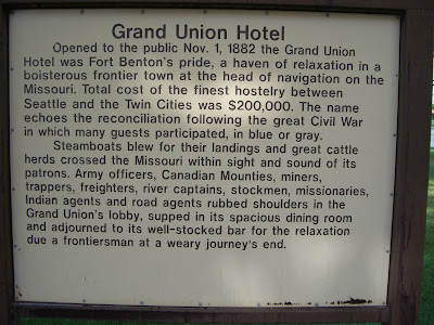
I have a thing for grand old historic hotels. It might have started when my family stayed at the Old Faithful Inn on a road trip to Yellowstone when I was in middle school. I even made DJ stay at the Davenport Hotel in Spokane over Christmas! The Grand Union is located right on the Levee in Fort Benton. Fort Benton’s historic district mostly faces the river, with a street running between the levee and the remaining buildings.


Our hotel, the Grand Union, and the Fort Benton levee, where steamboats unloaded trade goods for 50 years until the railroad arrived in Montana.
Built in 1882, just before steamboat traffic waned to railroad traffic, the Grand Union (http://www.grandunionhotel.com/) underwent a major restoration in 1999 and is a fabulous place to stay for a pretty reasonable price. They also have a fantastic dining room downstairs. Our room wasn’t quite ready when we checked in, so we walked along the tree lined levee, sat on the benches, checked out the bridge, and read the interpretive markers before going into our room. I’d made reservations for a room with a king bed, but somehow we walked into a room with two double beds. I promptly informed DJ that I loved him, but I was sleeping by myself tonight! I’m a sprawler, and he’s a cover-stealer, so two double beds were a great way to get a good night’s sleep!


Our hotel room, bathroom, and view out the window. Note the infernal air conditioner built into the ceiling? Note the restauraunt patio below?
After some lounging around and showering, we headed downstairs for dinner at the restaurant. DJ had a delicious steak, and I had a seafood pasta. I have to admit, I should have had the steak; the bites I stole were delicious!
After dinner we walked along the levee (www.fortbenton.com/levee/index.htm) back up to the BLM interpretive center. It was a nice way to help dinner settle before going to bed.  Unfortunately, the air-conditioning, or lack thereof, was a total buzz-kill. While our AC unit had worked while we lounged and showered, it no longer worked after dinner. But it did switch on every 20 minutes for 5 minutes to make this god-awful buzzing sound. Like the kind the old fashioned bed-side alarms used to make. We tried sleeping with the window open, which would have been fine save the infernal noise every 20 minutes, but the waitstaff was enjoying an after party on the patio below us. Finally. At 12:30 am I walked down and asked them to relocate. That left the AC unit to jolt us out of sleep every 20 minutes. I was so desperate for sleep that I even offered to go sleep in the back of the truck in the park. DJ, in true MacGuyver style, finally pulled out the screwdriver in a pocket knife, stood on the bed and unscrewed the vent, and hit the kill switch for the AC. Sweet, sweet silence (except for the crickets). After that we had a lovely night of sleep!
We woke slowly the morning of Saturday, the 4th of July, and both showered again before going downstairs for breakfast. After the continental breakfast served at our hotel in Hawaii, well, no other continental breakfast holds a candle. But we had something to eat and coffee, before checking out.
We retraced out steps to the Museum of the Northern Great Plains, and walked through the exhibits of homesteading, tractors, and the building petting zoo with authentic buildings hauled in from now-defunct homesteading towns. They did have a large collection of tractors!
We left Fort Benton around 1pm, and headed towards Great Falls for gas and the remainder of our trip. We left Fort Benton around 1pm, and headed towards Great Falls for gas and the remainder of our trip. I won’t go into our pit stop in Great Falls, but suffice to say, I remember now why we live in Bozeman, where dentists are abundant.
From Great Falls we went north on I-15 to Vaughn, where we turned west towards Sun River and Fort Shaw, which was built in the spring of 1867 to protect miners traveling the Fort Benton- Helena road. It is named after Colonel Robert Gould Shaw who commanded one of the first all African-American regiments, during the American Civil War.
From Fort Shaw I convinced DJ to do some off-roading. Rather than take highway 200 through Lincoln, we took the Birdtail Creek Road up towards Birtail Butte. Mullan’s road-construction journal describes Birdtail Butte frequently, and most of the resources I’ve found so far indicate the Mullan Road went south of Hwy 200.

What? Why wouldn't we high-tail it into the Montana backcountry. Where there is no cell service. Only cows. And people, with guns. Who are very insistient about their property rights. you don't think that was a good decision?
So up a dirt road we went! Along the way, I couldn’t help but notice the farmsteads we passed. Maybe they were stage coach stops on the Fort Benton-Helena Road, which was the Mullan Road?

Birdtail Butte is the result of volcanic, then later glacial activity that formed the landscape of Montana. It’s name is derived from how it looks like the feathers of a bird tail sticking out of the ground. Native Americans in the region used this passage across the mountains frequently, and would often leave offerings at the base of, or on top of, the butte.


Bird Tail Butte

Up up up

Down down down
Coming down Birdtail Pass we saw more farmsteads and ranching operations. More former stage-coach stops, perhaps?
From Birdtail, we ended up on MT HWY 287, and went south to I-15. Mullan’s road journals mention being within one mile of the Missouri River again. It must have been disheartening to come all this way from Fort Walla Walla, get to within one mile of the Missouri, but look east and realize you’ve still got to portage nearly 100 miles over Birdtail Pass.
From I-15, we took a cutoff from the Siben Ranch towards the Chevalier Ranch, crossed 279, and went up to Marysville. Ali Judge introduced me to Marysville a few years ago one interesting night in college. Ever since, I always take people up there when I’m in the area. Beginning in the 1870’s Marysville was a silver mining town (www.marysvillemontana.com/tour/index.html), and silver ore came from a mine called the Drumlummon (great name!) It died out after the USA switched from the silver standard to the gold standard for currency. The greatest surprise (for a girl who has been up there probably three times in the last five years) is that the road was paved!
After doing the drive-around in Marysville, we drove past Great Divide Ski area, and into the Continental Trail Road. I should add that our detour through Marysville to the CDT was not part of the Mullan Road; it skirted the eventual site of Marysville to the east but stayed just west of the eventual site of Helena. Anyway, the CDT was a lot of jostling around through the backcountry, and then we dropped into Mullan Pass.


The excellent driver, in his truck, on the BFE, I mean, CDT, road.
At an elevation of 5,902 feet, Mullan Pass is where the Mullan Road turned west to Garrison, Montana, then pretty much followed the current line of I-90 through Idaho to Coeur d’Alene, where it went south over the Palouse. The Northern Pacific built its line from Logan, MT (just west of Bozeman) through Garrison in 1883, and primarily used Mullan Pass to move freight after the main route when over Homestake Pass between Bozeman and Butte was completed. We were lucky enough to be there when a train went through. 

Train!
And I say through because the NP blasted a 3,847 foot long tunnel over through the last bit of the pass to avoid the last bit of altitude climb.

Mullan Pass
By rumor, and with some historical support, Mullan Pass was also the location of the formation of the Masonic society in Montana. Masons have played a role in Montana and were possibly the group who formed Vigilantes to hang road agents during the wild and lawless days of the gold rush.
 Looking west from Mullan Pass towards Helena.
We had to make a decision once we reached Mullan Pass at about 5pm on Saturday July 4. Bozeman, and our nice bed, with sheets, and a nice Sunday with coffee, was to the east, through Helna where we could have a nice dinner. OR, we could head south and west towards Garrison, continuing to follow the Mullan Road, and then swing through the Pintler Loop and try to find a camping spot on the 4th of July on Georgetown Lake. We’re not dumb. We decided to go home.

Proof that I was there too!
One plus was that as we came down towards Helena, we also got a nice look at the train trestle still in use. 
Huh! A train trestle!

I wonder when this one replaced a wood trestle?
 We grabbed dinner at the restaurant attached to the Holiday Inn on Last Chance Gulch, and then bolted for home. We were in bed by 10pm, and I swear to god, those fireworks were noisy! But we slept through them!
The next big Mullan project weekend is actually this week, when I drive back to the lake for 10 days. Stay tuned!
I enjoyed your posts about Mullan Road. My great-great-grandfather settled in present-day Clinton, MT. Clinton started out as a stage coach stop on the Mullan Road in 1883, and was originally called "Betters' Station," named after my ancestor, Austin Betters, who settled there around 1881. If you happen to have any information on the Clinton area from 1881 - 1911, I would appreciate it.
ReplyDelete