This 4th of July was the first I'd spent away from Lake Coeur d'Alene since 2003, when I was a camp counselor at a summer camp in New York. We, or I, chose not to go out to North Idaho for two reasons: my parents rented our lake place, meaning we'd have find a place to sleep at my grandparents over-crowded cabin; and my cousin is getting married in Uniontown this weekend, and I would have wanted to stay through the week, and DJ doesn't have the same kind of vacation time as I do.
We struggled with what to do with an open 4th of July weekend, one where we both, as local government workers, got Friday off too. We thought about going out to western Washington to see DJ's family. Thought about going to the Oregon coast. And then I started to get really antsy about a project I'm working on for the Montana Historical Society and convinced DJ that research in Montana would need to be done, and soon.
The project, which will culminate in a presentation over lunch at the Montana History Conference in October, is called "The Mullan Road: Stimulus to Settlement". Built in 1859-1860, the War Department funded the Mullan Wagon Road from Fort Walla Walla, Washington, to Fort Benton, Montana; the end of navigation on the Missouri River, to create a link between the two outposts as well as a way to dispatch troops between locations in the Pacific Northwest before the train arrived. Ironically, exactly one detachment of troops ever used it, but a number of early Montana settlers traversed it. My goal is to travel the length of the Mullan Road, where I can find it, and try to understand where along it settlement occurred and why. I'll also photograph a lot of it, and try to compare historic photos with photos I'll take this summer.
You see, the Mullan Road is kind of in my 'hood. Walla Walla, through the Palouse, then south of Cheney to the southern end of Lake Coeur d'Alene (this was rerouted north of C d'A in 1860), over basically I-90 to Garrison, Montana, then northeast to Mullan Pass, skirting around Helena and Great Falls and into Fort Benton. We travel the I-90 portion up to 10 times a year. Also, ever since I took a class from the great Karl Raitz at Kentucky, I’ve been fascinated by transportation geography.
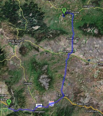
We left Bozeman on Thursday night and drove east to Big Timber, then north through Harlowton and Judith Gap to camp at Ackley Lake, about 20 miles south west of Lewistown. Richard Harlow founded Harlowtown in 1900 as a stop on the “Jawbone” Railroad, which he sold nine years later to the Milwaukee Road. DJ and I both have a crush on the Milwaukee Road, but that’s another post!


The Milwaukee Road put itself into debt in the 19teens to go electric instead of steam or diesel, and as a company never totally recoverd financially. When they went bankrupt in the 1970's and shut down so many Montana communities depended on the Milwaukee to move frieght and employ people that the governor's office came close to declaring a state of emergency.
 Note the caved in roof on the poured-in place concrete building?
We drove north of Harlo through Judith Gap and its wind turbines 


Wind farms, on land that is still being farmed. A combine fits under one of the blades with over 30 feet to spare.
and then west at “Eddie's Corner” to Ackley Lake State Park. Campers, RV’s and trailers packed the campground when we arrived at about 8:30pm, so we just pulled into a field in the state park to camp in. It’s a pretty low key type of place.  Unfortunately, the water was pretty high and the wind was blowing, so not only did we not have a tent camping spot, but we couldn’t start a fire for s’mores! I haven’t camped in a tent since like 1997, and I love s’mores, and was really looking forward to both of those things. Oh well, truck camping and BBQ’d hamburgers (without condiments- DJ forgot to pack them) and then to bed for some reading.
We woke up on Friday, and got out of the campground at about 8:30am. By 9am we were in Lewistown, drinking coffee and walking around.

Coffee. The big cup is mine.
The first incident of the day occurred when I spilled my coffee down my shirt. I really have no coordination or fine motor skills. Awesome. Nothing looks more professional than coffee on your boobs as you try to have a serious conversation with someone about a historic resource! So we had to drive out to the fairgrounds where I quickly changed into a sundress.
Lewistown is pretty awesome. Many of the older buildings have this incredible stonework done by Croatian immigrants to the area during the Homesteading Era of 1900-1919.

Check out the texture on the buildings!
They’ve also done a nice job of adaptive re-use, including turning the Fergus County High School Building into apartments, with the parking garage in the gym!!!


The Fergus County High School, now apartments with parking in the gym! I wonder how many former students who swore that they'd never step foot in the building again now reside there?
The last thing we checked out in Lewistown before leaving was the airport, which still uses its Deperssion Era hangar! Cool!

We left Lewistown about 11am and headed north and west towards Fort Benton. Stay tuned for the rest of the story! (I miss Paul Harvey).