Oh, hi, I have a blog?
Sorry for being absent for the last 11 days (eek!). I did the Mullan Road presentation to the Montana Historical Society on Saturday. I’m relieved to say it went well, but also embarrassed to admit that it took a lot of last minute scrambling to make the presentation halfway decent. And I’m glad no one asked for a bibliography, because while I know where all of the images came from… I um, didn’t ask the Washington Historical Society if I could borrow them. I will! I will!
But overall the Montana History Conference was good. It was awesome to get to meet some fun people, and commiserate about how difficult this job can be sometimes. And yeah, they’re doing some awesome projects in Billings; it kind of makes Bozeman look backwater..
I sprinted back from Fort Benton on Saturday afternoon in order to get home in time to make it to Mandi and Jason’s wedding reception, which was super fun. We made it there in time to miss the cake, but did drink and dance a bit, before making an appearance downtown at the Cannery. Always fun to see old friends. Yet, still, I’m still super snarky about weddings. It took me about 30 minutes (and two glasses of wine) to quit being standoffish and join in the fun. What’s my deal?
In other news, the contractor blew my mind this morning when he told me we’d probably be able to move into the house at the END OF NEXT WEEK. DUDE. That’s like 10 days. Like, we haven’t even ordered the light fixtures (which are supposed to go in on Wednesday)… like, holy mother of god 10 DAYS. WOHOOO!
Of course, we’ll probably end up moving in on Halloween, which happens to coincide with the Preservation Board’s hosting of a lecture and cemetery tour. Awesome. Nothing like being massively overbooked.
Now that the Mullan Road is behind me (ha! A transportation joke!), I’m starting to work on Wedding stuff. Well… make that starting to make lists about working on wedding stuff. We’ll see how much I get done!
About Me
- Courtney
- Blogging about gardening in zone 4, marriage, our golden retriever and life in general.
Showing posts with label Mullan Road. Show all posts
Showing posts with label Mullan Road. Show all posts
Monday, October 19, 2009
Monday, September 14, 2009
Back in the saddle… or out of it?
We arrived back in Bozeman on Sunday night at about 7pm. Roadtip of 40 hours of drive time. We stopped by the house, and look at what we found:
It’s framed! The roof sheeting is even on. The garage walls are framed and I expect they’ll put the garage roof trusses on today. The plumber has been working on putting that crucial aspect together. We’ll probably meet with the builder on site Monday afternoon to talk about a few framing tweaks and electrical stuff. I think we need to make a decision on exterior materials and color early this week; including roofing. We’re still leaning towards a yellow house; yellow lap siding, natural stained shake in the upper third and white trim on the windows, porches, doors, etc.

 View out of the west front bedroom windows.
 View out of the east front windows.
  This is the best view from the house. It is in our master bedroom window, looking north to the Bridger Mountain Range. The slope of the roof is pretty shallow and I wanted to utilize this view so the window will be paired hung windows (the slide up kind). The little green strip to the right of the photo next to the street is a trail access, so this is our view forever! Wohoo!
Hey there's a house there! And a garage framed behind it!
It’s framed! The roof sheeting is even on. The garage walls are framed and I expect they’ll put the garage roof trusses on today. The plumber has been working on putting that crucial aspect together. We’ll probably meet with the builder on site Monday afternoon to talk about a few framing tweaks and electrical stuff. I think we need to make a decision on exterior materials and color early this week; including roofing. We’re still leaning towards a yellow house; yellow lap siding, natural stained shake in the upper third and white trim on the windows, porches, doors, etc.

The sideporch roof is on, and the posts for the roof. This is the backdoor of the house. Since this area inside (the foyer) will have a tile floor, we will usually exit the garage through the man door, come onto the porch, under the collonade, and in the backdoor onto the tile. Good for snowy shoes!

From the garage looking towards the house. The big opening to the right is a set of French doors that open out onto the porch.

The gap between the garage and the house. The decking will be at about the floor height of the house. I hate stepping out a door and down.
It’s framed! The roof sheeting is even on. The garage walls are framed and I expect they’ll put the garage roof trusses on today. The plumber has been working on putting that crucial aspect together. We’ll probably meet with the builder on site Monday afternoon to talk about a few framing tweaks and electrical stuff. I think we need to make a decision on exterior materials and color early this week; including roofing. We’re still leaning towards a yellow house; yellow lap siding, natural stained shake in the upper third and white trim on the windows, porches, doors, etc.
View out of the west front bedroom windows.  View out of the east front windows. This is the best view from the house. It is in our master bedroom window, looking north to the Bridger Mountain Range. The slope of the roof is pretty shallow and I wanted to utilize this view so the window will be paired hung windows (the slide up kind). The little green strip to the right of the photo next to the street is a trail access, so this is our view forever! Wohoo!
The bids are also in for the cabinets, countertops and flooring. Now we need to sort things through and figure out what our priorities are for spending money. Basically, we’re in agreeance that the downstairs finishes take priority; I’d rather have awesome granite countertops in the kitchen and laminate in the master bathroom… then replace the master bathroom countertops if we feel like it someday.  Backyard sunset.

 From the west looking east.
You’ll also notice that it was a beautiful evening and sunset!

::::::::::::::::::::::::::::::::::::::::::::::::::::::::::::::::::::::::::::::::::::::::::::::::::::::::::::::::::::::
Now, onto the vacation recaps!
We got out of Bozeman at about noon on the Friday before Labor Day and booked it west towards my Grandma Joyce’s in Colton, where my mom had put together a quick BBQ with our family and my two grandmothers and one grandfather.
Along the way, I needed to do some Mullan Roading. While I was in the Montana Historical Society Archives in Helena, MT in May, I came across this great pamphlet done by Jon Axline of the Montana Department of Transportation about the “Point of Rocks” segment of the Mullan Road, outside of Alberton, MT. It included a map and information, and our earlier attempts to visit the area were rained out. We got there (Alberton Exit, #75) at about 3pm, and since it was only about 85 degrees and blisteringly sunny, decided to walk around.

The area is easy to find, and is adjacent to both I-90 and the old Milwaukee Roadbed. We drove down the Milwaukee line and stopped at the overgrown parking area. The maps and pamphlet indicated the area is owned by MDOT through a three way land swap, so I felt comfortable hiking around in there, but probably wouldn’t have done it without DJ there. Despite traffic wizzing by ay 75-90 miles an hour below, the walking “trail” still felt pretty isolated.
 Interpretive signage by the Mondana Department of Transportation.

Out of the trailhead you walk through the gate and along the Milwaukee Roadbed for a bit, and then hang a right and head up the hill. This genius wore a sundress, but did at least think enough to put on tennis shoes. It’s not quite a “trail”; it’s an overgrown road (hello, Mullan Road!), and weeds were waist high and no fun to tramp through in bare legs. But I’m tough. All in the name of cool old shit.
 The whole area was exposed in 2005 after a fire along this hillside wiped out the vegetation in the area. Despite what a Subaru-driving tree hugger might tell you, forest fires can actually be good things. In this instance, the fire burned off 154 years of overgrowth that camouflaged the Mullan Road, as well as roads cut into the area built so the Milwaukee Road could build its line through here in 1908. Since that fire, the weeds have come back, but it is still passable.

Backyard sunset. From the west looking east.
 You’ll also notice that it was a beautiful evening and sunset!

::::::::::::::::::::::::::::::::::::::::::::::::::::::::::::::::::::::::::::::::::::::::::::::::::::::::::::::::::::::
Now, onto the vacation recaps!
We got out of Bozeman at about noon on the Friday before Labor Day and booked it west towards my Grandma Joyce’s in Colton, where my mom had put together a quick BBQ with our family and my two grandmothers and one grandfather.
Along the way, I needed to do some Mullan Roading. While I was in the Montana Historical Society Archives in Helena, MT in May, I came across this great pamphlet done by Jon Axline of the Montana Department of Transportation about the “Point of Rocks” segment of the Mullan Road, outside of Alberton, MT. It included a map and information, and our earlier attempts to visit the area were rained out. We got there (Alberton Exit, #75) at about 3pm, and since it was only about 85 degrees and blisteringly sunny, decided to walk around.

Walking west along the Milwaukee Road.
The area is easy to find, and is adjacent to both I-90 and the old Milwaukee Roadbed. We drove down the Milwaukee line and stopped at the overgrown parking area. The maps and pamphlet indicated the area is owned by MDOT through a three way land swap, so I felt comfortable hiking around in there, but probably wouldn’t have done it without DJ there. Despite traffic wizzing by ay 75-90 miles an hour below, the walking “trail” still felt pretty isolated.
 Interpretive signage by the Mondana Department of Transportation.
Sure! Why not?
Out of the trailhead you walk through the gate and along the Milwaukee Roadbed for a bit, and then hang a right and head up the hill. This genius wore a sundress, but did at least think enough to put on tennis shoes. It’s not quite a “trail”; it’s an overgrown road (hello, Mullan Road!), and weeds were waist high and no fun to tramp through in bare legs. But I’m tough. All in the name of cool old shit.
 The whole area was exposed in 2005 after a fire along this hillside wiped out the vegetation in the area. Despite what a Subaru-driving tree hugger might tell you, forest fires can actually be good things. In this instance, the fire burned off 154 years of overgrowth that camouflaged the Mullan Road, as well as roads cut into the area built so the Milwaukee Road could build its line through here in 1908. Since that fire, the weeds have come back, but it is still passable.
We walked the entire segment, which winds through the rocks on the bluff on the north side of the river, before looping back down to the Milwaukee’s tunnel through the area and railroad bed. The wagon road is little more than a trace through the hillside. It’s narrow, and as it hugs the terrain I imagine that the corners would nearly unmaneuverable for a vehicle traveling more than five miles per hour. 
Walking it is slow going; since the road has to account for the rock formations that Mullan’s men didn’t have the time or black powder (it was 1859) to blast through. In choosing a route, Mullan had to consider both the fastest and most direct route while also being mindful of the endurance of the oxen or horses which would pull wagons or carriages through the section. The Point of Rocks section is a long ways from either end of the trail in Walla Walla or Fort Benton.
 With this in mind, walking this segment of the road is probably a mile and a half of doubling back along a drainage and hiking above where you’ve just been, but only three quarters of a mile as the crow flies in a direct line. The juxtaposition of the Milwaukee Roadbed below and Interstate 90 just a bit further to the south in addition to the slow moving Clark Fork River really make this wagon road a marvel in outdated road civil engineering.


While standing in the blistering September sun, on a bluff overlooking the Clark Fork River and listening to semi’s wiz by on I-90 below, I started thinking about how historic preservation professionals measure a site’s historic significance. Specifically, “Feeling” is one of the Secretary of the Interior’s seven items of Integrity for a historic site. If the site can’t convey its originality of location, materials, site, association, and feeling, etc., it doesn’t have enough integrity to convey its historic significance. As you can imagine, explaining or defining “feeling” is difficult. How does one quantify feeling? In this case, walking along a 15-20 wide section of roadway which winds in and out of a hillside in segments so narrow that a modern automobile could not pass through, I can say that I “felt” what it was like to travel the Mullan Road.


This section of the road is not yet listed on the National Register of Historic Places, although Jon Axline is working to have it listed. It is available to the public, and there is interpretive signage on the site, but there is little advertising the site for public use. But if you’re in Alberton, and need a good hike, I can recommend a place!


 After Mullan Roading, we sprinted for Colton, and got there in time for late hamburgers with the grandparents, parents, sister and uncle. It was a fun, funny, laid back gathering of people. Gretchen tried on her bridesmaid dress for the wedding (it fit!), I borrowed Grandma Joyce’s wedding dress, which I’m going to wear for the wedding, and everyone had a chance to ooohhh and ahh over my engagement ring and us. It was fun; but the real punch line was when they started telling stories about people they know. They had poor DJ’s head spinning around with all of the side stories, back stories, relatives, backroads, family feuds, etc. Poor guy!
Another great part was how peppy my Grandpa Bob was. He’s been struggling as he’s in his mid 80’s; can’t drive anymore and has lost most of the use of his left side. For a guy used to working outside with his hands (as a farmer), the loss of his mobility and usefulness has been hard for his psyche. But in the summers he can be out roaming around, and he even reminded me that he owes me a trip up around Steptoe Butte. I need to make time to take him up on that!
From Colton we went down to Clarkston to stay at my mom and dad’s condo. More later!
 With this in mind, walking this segment of the road is probably a mile and a half of doubling back along a drainage and hiking above where you’ve just been, but only three quarters of a mile as the crow flies in a direct line. The juxtaposition of the Milwaukee Roadbed below and Interstate 90 just a bit further to the south in addition to the slow moving Clark Fork River really make this wagon road a marvel in outdated road civil engineering.

While standing in the blistering September sun, on a bluff overlooking the Clark Fork River and listening to semi’s wiz by on I-90 below, I started thinking about how historic preservation professionals measure a site’s historic significance. Specifically, “Feeling” is one of the Secretary of the Interior’s seven items of Integrity for a historic site. If the site can’t convey its originality of location, materials, site, association, and feeling, etc., it doesn’t have enough integrity to convey its historic significance. As you can imagine, explaining or defining “feeling” is difficult. How does one quantify feeling? In this case, walking along a 15-20 wide section of roadway which winds in and out of a hillside in segments so narrow that a modern automobile could not pass through, I can say that I “felt” what it was like to travel the Mullan Road.


This section of the road is not yet listed on the National Register of Historic Places, although Jon Axline is working to have it listed. It is available to the public, and there is interpretive signage on the site, but there is little advertising the site for public use. But if you’re in Alberton, and need a good hike, I can recommend a place!


 After Mullan Roading, we sprinted for Colton, and got there in time for late hamburgers with the grandparents, parents, sister and uncle. It was a fun, funny, laid back gathering of people. Gretchen tried on her bridesmaid dress for the wedding (it fit!), I borrowed Grandma Joyce’s wedding dress, which I’m going to wear for the wedding, and everyone had a chance to ooohhh and ahh over my engagement ring and us. It was fun; but the real punch line was when they started telling stories about people they know. They had poor DJ’s head spinning around with all of the side stories, back stories, relatives, backroads, family feuds, etc. Poor guy!
 Another great part was how peppy my Grandpa Bob was. He’s been struggling as he’s in his mid 80’s; can’t drive anymore and has lost most of the use of his left side. For a guy used to working outside with his hands (as a farmer), the loss of his mobility and usefulness has been hard for his psyche. But in the summers he can be out roaming around, and he even reminded me that he owes me a trip up around Steptoe Butte. I need to make time to take him up on that!
From Colton we went down to Clarkston to stay at my mom and dad’s condo. More later!
Wednesday, July 15, 2009
Going to the Lake
Make a list, make a spreadsheet. Pack a bag, pack a cooler. Hit the library and borrow some books, or a book on CD for the long drive. Clean the house; no one wants to come home to a gross house. Wrap up projects at work, set the email to return message people that you’re out. Water the plants, oh I hope the plants don’t get too dry!
Pack the cooler, pack the tote with food. Pack the bag, pack the book bag. Rush around, did you forget anything?
Close and lock the windows, shut the blinds. Lock the doors, did you lock the garage door?
Get in the car, gassed up last night. Hit the road, take Huffine west. Go north at Four Corners, then west at Belgrade. Ahh, Interstate 90, for the next 360 miles.
Discuss work, discuss the upcoming weekend. Eat crackers, drink water. Past Jeff and Suzy’s, through Three Forks. Thunderstorms going over Homestake Pass, lightning and cracks of thunder. Through Butte, too bad we’re missing the Folk Festival again.
Long straight shot through the Deer Lodge Valley, my the Pintler Mountains are beautiful this time of year. Especially in the evening, when the cotton trees are shedding cotton like snow.
Outside of Missoula, call Mackenzie River Pizza Co for a pick-up order. They’re right there on the Grant Creek exit, next to the gas station. Athenian vegetarian pizza, with chicken, please.
Get gas, get pizza. Go pee in Mackenzie River, its nicer. Hit the road, eating pizza from the box. DJ drives and eats, I just pass the napkins. Good pizza, not much left!
The road starts to wind in Alberton, along the Clark Fork River. I’d like to float the Clark Fork someday, from Missoula to Saint Regis. Hey, we’re along Captain Mullan’s Road, from Garrison to Harrison!
Outside of Superior there’s a farm on the Clark Fork, beautiful setting if you don’t count the highway rolling past it. I’d have built my farm there, overlooking the river in a scenic mountain valley.
Through St. Regis, where the St. Regis de Borgia River joins the Clark Fork River. They flow north from St. Regis, into Flathead Lake. From St. Regis it feels all uphill, to the top of Lookout Pass. We drive west, why do we always drive west as the sun is setting? Because we try to sneak an extra day in by leaving work early, in order to arrive at the lake in the evening.
Up the big hill, past the highway sign where deer congregate. Over Lookout Pass, oh the view! Mullan went one mile south of here, naming it Sohon Pass for his artist.
Down towards the town of Mullan, watch for speed traps. Past Wallace, I remember I-90 under construction here. We should stop some time, and see the last brothel in Idaho. Through Kellog, we should ski at Silver Mountain one winter.
Still west, past the Cataldo Mission. Moved to that location in the 1840’s, from another site near Saint Marie’s. Great historic site, on the Coeur d’Alene River. We could get there by jet ski from Harrison, we should do that some day.
Our exit is only a few miles from the Mission, exit 34. Off the interstate, going south through the Coeur d’Alene River Valley. Past Rose Lake, remember the flood last year?
Past Medimont, up the hill. On the flat now, turn onto Highway 3. Past the farmland, oh smell the air! The wheat is blooming, reminds me of Eastern Washington. It is dusk, watch for deer.
Down the hill, I see the lake!!! Slow way down, Harrison: Population 267. Don’t turn here, we’ve got to drive past One Shot’s! It’s for sale, hmm… retirement plan?
Drive down Lakefront, into the house. The neighbors are here, their place looks nice. Get out of the car, streeeeeettttcchhh. Finally, we’re here.
Unpack the car, unload the cooler. Take the food tote in, take the bags in. Ahh, look at that view! The lake, the hills. The light across it, just now at dusk. Let’s have a drink, a nightcap on the deck.
The drive is worth it, don’t you think?
Monday, July 13, 2009
4th of July Roadtrip Recap (Part 2)
We left Lewistown about 11am and headed north and west towards Fort Benton. The first 50 miles or so outside of Lewistown generally reflect Montana’s homesteading heritage and the vastness of the Great Plains. I couldn’t justifiably capture the space- I’d need a panoramic camera (or two!). It is an amazing thing to see a thunderstorm 30 miles off as you zip towards the huge buttes and mountains on the western horizon. Out both sides of the windows farmsteads, some abandoned and consolidated into the neighboring property, are relics of Montana’s Homesteading rush of the early 1900’s. It amazed me to consider that in a scant 100 period these homes were built, lived in, improved and then either succeeded or failed and withered.
The landscape changes as you pass through Coffee Creek and then go into the Square Butte and Denton area. Instead of dry land farming, it becomes cattle country, with corrals, broken buttes, dry creek beds, but still with the same vastness of space. Unfortunately, my photos out the car window are so poor that I can’t even bear to try to post them here. They just don’t even come close to capturing the sense of SPACE out there!
We arrived in Fort Benton at about noon, apparently just missing a storm with ¾ inch hail outside of Geraldine. Our first stop was the Missouri Breaks Interpretive Center, run by the Bureau of Land Management.
 The BLM Interpretive Center
The plaza in front of the building gives visitors a sense of which direction people headed out of Fort Benton after getting off of a Missouri River steamboat in the 19th century. Virginia City, Last Chance Gulch, the Whoop Up Trail into Canada, Cow Island, and other places only accessible by wagon until the railroad arrived in the 1880’s.  Mullan Road from Fort Benton to Walla Walla, Washington.
At the BLM center we bought two, two day passes to all of the museums in Fort Benton. We watched a quick documentary of the area, then drove down to the fort of Fort Benton and toured the reconstructed buildings.

All that remains of the original adobe walled fort. Only the mortar!
The Daughters of the American Revolution stabilized the blockhouse building in 1908, making it one of the oldest buildings in Montana. The rest of the buildings on the site are reconstructions, and a major reconstruction project is planned for the remainder of the site.

The building to the left is reconstructed from photos and archaeological findings. The square building on the right was stabilized by the Daughters of the American Revolution in 1908.
The Museum closed at 4pm, so we took a quick look at the Hornaday Buffalo in the lobby, and decided to come back in the morning. We headed over to our hotel and checked in for the night.
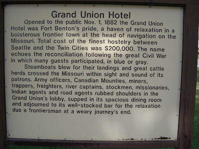
I have a thing for grand old historic hotels. It might have started when my family stayed at the Old Faithful Inn on a road trip to Yellowstone when I was in middle school. I even made DJ stay at the Davenport Hotel in Spokane over Christmas! The Grand Union is located right on the Levee in Fort Benton. Fort Benton’s historic district mostly faces the river, with a street running between the levee and the remaining buildings.


Our hotel, the Grand Union, and the Fort Benton levee, where steamboats unloaded trade goods for 50 years until the railroad arrived in Montana.
Built in 1882, just before steamboat traffic waned to railroad traffic, the Grand Union (http://www.grandunionhotel.com/) underwent a major restoration in 1999 and is a fabulous place to stay for a pretty reasonable price. They also have a fantastic dining room downstairs. Our room wasn’t quite ready when we checked in, so we walked along the tree lined levee, sat on the benches, checked out the bridge, and read the interpretive markers before going into our room. I’d made reservations for a room with a king bed, but somehow we walked into a room with two double beds. I promptly informed DJ that I loved him, but I was sleeping by myself tonight! I’m a sprawler, and he’s a cover-stealer, so two double beds were a great way to get a good night’s sleep!


Our hotel room, bathroom, and view out the window. Note the infernal air conditioner built into the ceiling? Note the restauraunt patio below?
After some lounging around and showering, we headed downstairs for dinner at the restaurant. DJ had a delicious steak, and I had a seafood pasta. I have to admit, I should have had the steak; the bites I stole were delicious!
After dinner we walked along the levee (www.fortbenton.com/levee/index.htm) back up to the BLM interpretive center. It was a nice way to help dinner settle before going to bed.  Unfortunately, the air-conditioning, or lack thereof, was a total buzz-kill. While our AC unit had worked while we lounged and showered, it no longer worked after dinner. But it did switch on every 20 minutes for 5 minutes to make this god-awful buzzing sound. Like the kind the old fashioned bed-side alarms used to make. We tried sleeping with the window open, which would have been fine save the infernal noise every 20 minutes, but the waitstaff was enjoying an after party on the patio below us. Finally. At 12:30 am I walked down and asked them to relocate. That left the AC unit to jolt us out of sleep every 20 minutes. I was so desperate for sleep that I even offered to go sleep in the back of the truck in the park. DJ, in true MacGuyver style, finally pulled out the screwdriver in a pocket knife, stood on the bed and unscrewed the vent, and hit the kill switch for the AC. Sweet, sweet silence (except for the crickets). After that we had a lovely night of sleep!
We woke slowly the morning of Saturday, the 4th of July, and both showered again before going downstairs for breakfast. After the continental breakfast served at our hotel in Hawaii, well, no other continental breakfast holds a candle. But we had something to eat and coffee, before checking out.
We retraced out steps to the Museum of the Northern Great Plains, and walked through the exhibits of homesteading, tractors, and the building petting zoo with authentic buildings hauled in from now-defunct homesteading towns. They did have a large collection of tractors!
We left Fort Benton around 1pm, and headed towards Great Falls for gas and the remainder of our trip. We left Fort Benton around 1pm, and headed towards Great Falls for gas and the remainder of our trip. I won’t go into our pit stop in Great Falls, but suffice to say, I remember now why we live in Bozeman, where dentists are abundant.
From Great Falls we went north on I-15 to Vaughn, where we turned west towards Sun River and Fort Shaw, which was built in the spring of 1867 to protect miners traveling the Fort Benton- Helena road. It is named after Colonel Robert Gould Shaw who commanded one of the first all African-American regiments, during the American Civil War.
From Fort Shaw I convinced DJ to do some off-roading. Rather than take highway 200 through Lincoln, we took the Birdtail Creek Road up towards Birtail Butte. Mullan’s road-construction journal describes Birdtail Butte frequently, and most of the resources I’ve found so far indicate the Mullan Road went south of Hwy 200.

What? Why wouldn't we high-tail it into the Montana backcountry. Where there is no cell service. Only cows. And people, with guns. Who are very insistient about their property rights. you don't think that was a good decision?
So up a dirt road we went! Along the way, I couldn’t help but notice the farmsteads we passed. Maybe they were stage coach stops on the Fort Benton-Helena Road, which was the Mullan Road?

Stagecoach stop?
Birdtail Butte is the result of volcanic, then later glacial activity that formed the landscape of Montana. It’s name is derived from how it looks like the feathers of a bird tail sticking out of the ground. Native Americans in the region used this passage across the mountains frequently, and would often leave offerings at the base of, or on top of, the butte.


Bird Tail Butte

Up up up

Down down down
Coming down Birdtail Pass we saw more farmsteads and ranching operations. More former stage-coach stops, perhaps?
From Birdtail, we ended up on MT HWY 287, and went south to I-15. Mullan’s road journals mention being within one mile of the Missouri River again. It must have been disheartening to come all this way from Fort Walla Walla, get to within one mile of the Missouri, but look east and realize you’ve still got to portage nearly 100 miles over Birdtail Pass.
From I-15, we took a cutoff from the Siben Ranch towards the Chevalier Ranch, crossed 279, and went up to Marysville. Ali Judge introduced me to Marysville a few years ago one interesting night in college. Ever since, I always take people up there when I’m in the area. Beginning in the 1870’s Marysville was a silver mining town (www.marysvillemontana.com/tour/index.html), and silver ore came from a mine called the Drumlummon (great name!) It died out after the USA switched from the silver standard to the gold standard for currency. The greatest surprise (for a girl who has been up there probably three times in the last five years) is that the road was paved!
After doing the drive-around in Marysville, we drove past Great Divide Ski area, and into the Continental Trail Road. I should add that our detour through Marysville to the CDT was not part of the Mullan Road; it skirted the eventual site of Marysville to the east but stayed just west of the eventual site of Helena. Anyway, the CDT was a lot of jostling around through the backcountry, and then we dropped into Mullan Pass.


The excellent driver, in his truck, on the BFE, I mean, CDT, road.
At an elevation of 5,902 feet, Mullan Pass is where the Mullan Road turned west to Garrison, Montana, then pretty much followed the current line of I-90 through Idaho to Coeur d’Alene, where it went south over the Palouse. The Northern Pacific built its line from Logan, MT (just west of Bozeman) through Garrison in 1883, and primarily used Mullan Pass to move freight after the main route when over Homestake Pass between Bozeman and Butte was completed. We were lucky enough to be there when a train went through. 

Train!
And I say through because the NP blasted a 3,847 foot long tunnel over through the last bit of the pass to avoid the last bit of altitude climb.

Mullan Pass
By rumor, and with some historical support, Mullan Pass was also the location of the formation of the Masonic society in Montana. Masons have played a role in Montana and were possibly the group who formed Vigilantes to hang road agents during the wild and lawless days of the gold rush.
 Looking west from Mullan Pass towards Helena.
We had to make a decision once we reached Mullan Pass at about 5pm on Saturday July 4. Bozeman, and our nice bed, with sheets, and a nice Sunday with coffee, was to the east, through Helna where we could have a nice dinner. OR, we could head south and west towards Garrison, continuing to follow the Mullan Road, and then swing through the Pintler Loop and try to find a camping spot on the 4th of July on Georgetown Lake. We’re not dumb. We decided to go home.

Proof that I was there too!
One plus was that as we came down towards Helena, we also got a nice look at the train trestle still in use. 
Huh! A train trestle!

I wonder when this one replaced a wood trestle?
 We grabbed dinner at the restaurant attached to the Holiday Inn on Last Chance Gulch, and then bolted for home. We were in bed by 10pm, and I swear to god, those fireworks were noisy! But we slept through them!
The next big Mullan project weekend is actually this week, when I drive back to the lake for 10 days. Stay tuned!
Subscribe to:
Posts (Atom)